2024 : le Parc du Luberon a 47 ans
Solgne Louis 2024-01-30T10:14:46+01:00Le Parc du Luberon a été créé le 31 janvier 1977.


Le Parc du Luberon a été créé le 31 janvier 1977.
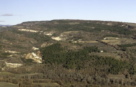
This site reproduces and illustrates on a smaller scale what happens on a larger scale in the Luberon massif. It is a "miniature Luberon." Location: Vaugines (84) Site type: Remarkable geological formation Parking The site of Déboulière, sometimes called La Garrigue, is 2.5 kilometers long and 500 meters wide. It stands out distinctly in the landscape as a small hill emerging from the cultivated plains. This small structure is an anticlinal fold (arched up), situated in the midst of the Durance plain. The particularity of this anticlinal is observable on its southern flank: Hauterivian limestones, dating back 130 million years old, are covered by 20 million years old Miocene marine sands, and then, again, by Hauterivian limestones. The sands were deposited on the Lower [...]
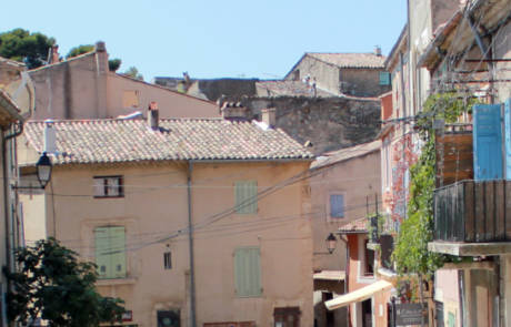
Le village de Viens, perché sur le rebord du plateau des Courennes, offre vers l’Est une splendide vue balayant les paysages de la Montagne de Lure au Luberon. Et n’oubliez pas d’aller visiter le cœur du village. Passé la ceinture de remparts, se découvre un dédale de ruelles et de places, bordées de belles demeures.
Le moulin de Salignan abrite une petite exposition géologique permanente sur le découpage des temps en géologie et l’étage Aptien.
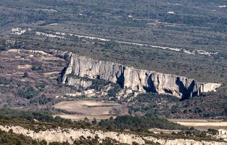
The Earth is a living planet animated by movements. This results in deformations, such as folds, fractures and faults like the particularly impressive one that overlooks the village of Lioux. Location : Lioux (84) Site type: remarquable relief, viewpoint Parking The Madeleine Cliff, which is 7 kilometers long and 80 meters high, is a magnificent escarpment of a fault. A fault is a fracture in the rocks with a relative displacement of one block with respect to the other along a plane called the fault plane. Movements of compression, extension, or shearing cause different types of faults: normal, reverse, and strike-slip. The Lioux cliff highlights the presence of a normal fault oriented NE-SW within the massive and thick limestone that forms the large mass [...]
Located at the eastern end of the Luberon, the Volx Rocks appear to be a homogeneous rock formation. In reality, they are made up of limestone blocks cemented together. They witness the activity of the Moyenne Durance Fault approximately 30 million years ago. Location: Volx (04) Site type : geological formation Parking The Volx Rocks correspond to a large anticlinal fold (an arched fold), which exposes the ancient rocks that outcrop further east in the Grand Luberon. This anticlinal structure is highly eroded in its center and is carved by two large valleys, Sarzen and Margaridètes, which reveal its marly core. Erosion here is spectacular, with intense gullying in the soft marls. The Fontamaurri stream (source of the Fontaines) emerges at the contact with [...]
L’Éducation à l’Environnement et au Territoire constitue une action inhérente à un parc naturel régional : ces territoires portent en effet un projet de développement durable, ambitieux et concerté, qui ne pourra réussir que par une adhésion large de leurs acteurs, de leurs habitants. Comment partager ces territoires remarquables par leurs patrimoines, et permettre de conserver ces singularités ? Comment partager des projets de territoire répondant au défi majeur que représente leur adaptation face aux enjeux écologiques, énergétiques, économiques, sociaux… ? Le Parc du Luberon, au travers du Programme d’actions éducatives à destination des scolaires, propose de travailler autour de quatre principaux enjeux pour le territoire qui se déclinent en plusieurs thématiques. S’adapter aux changements climatiques Longtemps objet de débats scientifiques houleux, le réchauffement [...]
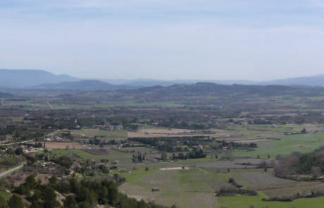
The village of Saint-Saturnin-lès-Apt is located on the southern slope of the Monts de Vaucluse. Built on a rocky spur, it offers an exceptional panorama of the Luberon, the Alpilles, and the Monts de Vaucluse, as well as a stunning view of the plain between Roussillon and Villars. Location: Saint-Saturnin-lès-Apt (84) Site Type: Remarkable village, Scenic viewpoint Visit Duration: 1 to 2 hours Saint-Saturnin-lès-Apt is a quintessential Provençal village nestled on the southern slopes of the Monts de Vaucluse. To the north of the village, the Lower Cretaceous limestone outcrops are visible. To the south, you will find Aptian marls. As you descend toward Apt and Gargas, these marls are covered by alluvium and topped with small hills where tertiary sands, limestone, clays, and [...]
Breathtaking panorama of the village of Gordes, ranked as 'one of the most beautiful villages in France'. Location: Gordes (84) Site type: Remarkable village, Scenic viewpoint The village of Gordes, perched on its rock, is located within the Monts de Vaucluse, between Apt and Avignon. The stunning panorama from Gordes offers breathtaking views of the village and a clear vista of the Calavon Valley extending to the Monts de Vaucluse and the Luberon massif. From here, one can admire the dry stone houses cascading along the streets up to the church and the castle. The village sits on the edge of a plateau made of highly fossiliferous limestone sandstone known as "molasse" or "Pierre du Midi". This rock was deposited in the Miocene sea [...]
Cucuron est l'un des "villages géologiques" du Luberon. Son nom, sa position dominante dans le paysage, les roches qui le portent et celles qui l'entourent, témoignent d'une histoire géologique mouvementée et des relations qui unissent l'Homme et le minéral. Vous découvrirez les richesses paléontologiques, archéologiques et ethnographiques de Cucuron au Musée Marc Deydier. Commune : Cucuron (84) Nature du site : Village remarquable, Formation géologique remarquable Le Musée Marc Deydier Des fossiles de Cucuron sont exposés au Musé Marc Deydier où deux nouvelles salles d'exposition ont été créées en 2024 pour valoriser le patrimoine géologique et paléontologique remarquable de la commune en lien avec les travaux de Marc Deydier. Le Musée de Cucuron créé en 1970 sur une initiative associative et communale est installé [...]